Marine Navigation
- 3.5
- Rating
- 10.00K
- Installs
- $19.99
- Price
 Analysis by App-foxy
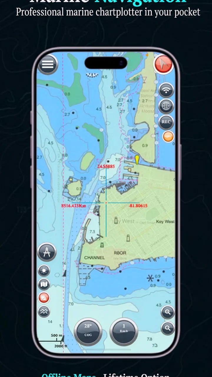
When I first look at a marine navigation app, I want to know one thing before anything else: will it help me turn a chart into a practical decision on the water, or will it simply add another complicated screen to the trip? Marine Navigation, developed by Marco Palaferri, is aimed at boaters who want to work with S57 charts and custom maps rather than rely only on a general-purpose navigation service. That focus makes it feel more like a specialist chart tool than a typical road-navigation app adapted for boats.
The app sits in the Maps & Navigation category, carries an Everyone age rating, and has been available since July 2012. Its current version is 16.8.18, and it runs on Android 6.0 or later. Those details matter because this is not a brand-new experiment: it has had time to develop a dedicated audience, although its average rating of 3.5 from over 400 ratings suggests that the experience is useful for some boaters but not universally smooth.
My overall impression is that Marine Navigation is best understood as a focused working tool, not a polished all-purpose boating companion. If you already know what chart material you need and are comfortable managing maps yourself, it can be valuable. If you expect an app to provide a complete, effortless marine service immediately after installation, the learning curve and purchase model may feel less welcoming.
You May Also Like

 Blood Strike: 2.5 Anniversary
Blood Strike’s Loadouts Turn Every Drop Into a Tactical Gamble
A close look at Blood Strike’s custom loadouts: how fast access to signature weapons reshapes its battle royale rhythm, rewards preparation, and narrows the gap between fights.

 Pandora - Music & Podcasts
Pandora’s Music Is Easy to Start, but Harder to Recover
Pandora’s strength is its low-effort path from a seed to a station. Its weak spot is how much confidence it asks you to place in connection, setup, and quiet recovery.

 8 Ball Pool
 Is Built on Rivalries, Rematches, and Routine
A close look at the rivalries, rematches, shared routines, and unanswered safety questions that turn a quick pool match into a persistent mobile community.

 Samsung Music
’s Quiet Strength Is Playing What You Already Own
Its reach comes less from spectacle than from dependable access to a personal library. That simplicity is both the app’s strongest retention engine and its ceiling.

 AccuWeather: Weather Radar
AccuWeather Review: A Quick, Clear Forecast for Everyday Decisions
For everyday plans, the best forecast is the one you can understand quickly. AccuWeather makes rain timing, radar, and local conditions easy to act on, with a few trade-offs.

 Hill Climb Racing
Why Hill Climb Racing Still Turns Crashes Into One More Run
A tiny car, a bumpy hill and one more upgrade: Hill Climb Racing keeps resurfacing because its simple chaos makes every near-miss feel personal.
More From Our News Desk
View All News


From planning a trip to following the chart
I find that the most useful way to judge this section is to follow the chart through the whole trip rather than focus on the screen alone. Before departure, I would check that the map covers both the destination and the approach, then set a view that is easy to interpret underway. That small planning step can make a specialist chart workflow feel far more dependable when attention is divided.
Starting with the right kind of chart
The first important decision is whether this app matches the way you prepare for a trip. Its central appeal is support for S57 and custom maps. That points toward users who already work with marine chart files, regional chart sources, or personally prepared map material. It is a different starting point from opening a mainstream navigation app, entering a destination, and expecting the software to handle the rest.
That distinction is useful in real life. A sailor planning a coastal passage may already have chart files saved on a phone or tablet, while a small-boat owner may want to bring a custom map covering a local lake, harbor, or private survey area. In both cases, the value comes from putting the map you trust into a navigation workflow. The app is less interesting if you only want a simple destination marker and do not intend to manage chart sources.
I would prepare the chart material before leaving the dock. Importing or organizing files while moving, dealing with glare, weak connectivity, or a cold device is exactly the kind of task that turns a useful tool into a source of stress. A better routine is to install the app at home, check that the desired chart opens correctly, inspect the area at several zoom levels, and make sure the device can be used comfortably in its mounting position.
This preparation also answers a question many new users have: does paying for the app automatically mean every chart is included? The purchase should not be treated as a universal replacement for chart sourcing. Marine Navigation is the application itself; the usefulness of the final setup depends heavily on the map material you bring into it and how well that material fits your trip. Anyone comparing it with a subscription-based boating service should compare the complete cost and preparation effort, not just the app price.
Building a usable map setup
Custom maps are more than a novelty here. They can be particularly helpful when the official or familiar chart coverage does not match the exact place you need to inspect. A local boating club, marina, expedition planner, or experienced skipper may have a preferred map source that is not presented in the same way as a consumer navigation service. Keeping that material close to the rest of the navigation information can reduce the need to switch between unrelated apps.
There is a trade-off, though. Custom material gives flexibility, but it also transfers responsibility to the user. I would not assume that a custom map is current, complete, or suitable for navigation merely because it opens successfully. A map can display beautifully and still lack the warnings or detail needed for a particular passage. The practical rule is simple: treat imported material as part of your planning toolkit, then judge its reliability independently before using it for decisions on the water.
Another useful habit is to keep a clear distinction between planning layers and operational information. A custom map might be excellent for understanding a shoreline, locating a private mooring, or marking a familiar route. That does not automatically make it a substitute for every official navigational reference. Marine Navigation gives you a place to work with map information, but good seamanship still requires checking the source and purpose of each chart.
Moving from the screen to the boat
Once the chart is prepared, the next step is making the app usable in the physical environment of a boat. A phone or tablet mounted below the windshield may be exposed to reflections, vibration, spray, and changing brightness. I would test the display before departure rather than assume that a chart which looks clear indoors will remain readable in sunlight.
The same applies to touch controls. On a calm desk, zooming and panning are easy. On a moving boat, a small control can be harder to use accurately, especially when wearing gloves or trying to keep one hand available for another task. This is one reason I see the app as a companion to proper navigation habits rather than as something that should monopolize attention. Set the map view before a demanding section, keep the route context in mind, and avoid making the phone the only source of situational awareness.
For a realistic example, imagine leaving a marina for a short coastal run. Before casting off, I would open the relevant S57 chart, inspect the departure area, look ahead along the intended track, and use any custom map that adds local context. During the trip, I would keep the display at a practical scale instead of constantly zooming in and out. At a handoff point, such as changing watch or approaching a harbor, I would explain what the screen is showing rather than simply passing over the device. That small briefing matters because a chart app is only useful when the person taking over understands the same map view and assumptions.
Handling the handoffs
Handoffs happen in several places: from the chart provider to the app, from the app to the device, and from the device to the person steering or keeping watch. Marine Navigation’s strength is that it can sit in the middle of those transitions, bringing S57 and custom map material into one marine-focused workspace. Its weakness is that every handoff creates an opportunity for confusion.
The first handoff is file management. If a chart is stored somewhere unfamiliar, or if several versions of the same area exist, the user needs a naming and organization system. I recommend keeping one folder or clearly labeled collection for the trip, separating current working charts from older material, and opening each important file before departure. This is not glamorous, but it prevents the common mistake of selecting a chart that covers the destination while missing the approach.
The second handoff is between planning and live use. A map that was comfortable to study at home may not be the best view for following progress. I would create a simple pre-departure routine: confirm the area, check the chart scale, identify the next decision point, and then leave the app in a view that can be understood quickly. The goal is not to decorate the screen with information; it is to reduce the mental work required when conditions become busy.
The third handoff is between this app and the rest of the boat’s equipment. Some users will already have instruments, printed references, or another navigation solution. In that setting, Marine Navigation can serve as a flexible second view, a custom-map viewer, or a planning aid. I would be cautious about making it the sole authority unless the complete setup has been tested and suits the boat, the route, and the operator’s experience.
What the purchase model means in practice
The app is listed at $19.99, with in-app purchases shown at $5.99 per item. That makes the buying decision more involved than a simple free download. I would think about the total workflow before paying: the app cost, any additional items relevant to the setup, the time needed to prepare charts, and whether the custom-map support is genuinely useful for my destinations.
The one-time-purchase positioning is attractive to people who dislike recurring subscriptions. For a boater who uses the app over several seasons, paying once for the core application may feel more predictable than maintaining a monthly service. On the other hand, users who want automatic chart services, guided route planning, or a ready-made catalog may find a subscription product easier even if its long-term cost is less straightforward.
Because the app is paid, I would not recommend buying it casually just to see whether marine navigation interests you. The strongest reason to choose it is a specific need for S57 or custom-map work. If that need is clear, the price can be easier to justify. If it is not, a free map viewer or a mainstream boating app may be a better first step for learning what kind of navigation workflow you actually want.
Where the workflow produces a good result
When the chart source is suitable, the device is prepared, and the operator understands the map, the result is a more focused navigation experience than a general map application usually provides. Instead of forcing marine information into a road-oriented interface, Marine Navigation is built around the idea that the chart itself is the working surface.
I find that especially useful for people who move between different waterways and need more control over the map material they use. It can also suit experienced users who want to preserve a familiar chart workflow rather than learn the assumptions of a large navigation platform. The app’s modest install base—over ten thousand installs—does not prove quality by itself, but it does fit the impression of a specialist tool with a narrower audience rather than a mass-market navigation service.
The best outcome is not simply seeing a boat position on a screen. It is being able to answer practical questions quickly: what area am I looking at, which map source am I using, what is the next section of the trip, and does the chart provide the detail I expect? A focused app can help with that when it stays out of the way and the user has done the preparation.
There is also a privacy angle worth noticing. The store summary emphasizes respect for privacy, which will appeal to people who prefer a more contained navigation setup instead of a service built around extensive account features or advertising. I would still judge the app by the permissions and behavior shown on the device, but its privacy-oriented positioning is a meaningful part of its appeal for users who want a straightforward chart tool.
Where the workflow breaks down
The most likely point of failure is not the map display itself; it is the gap between what a user expects a navigation app to provide and what this specialized tool is designed to do. Someone accustomed to automatic route suggestions, traffic-style updates, or a polished onboarding sequence may find Marine Navigation demanding. The app assumes more involvement from the operator, particularly around map selection and preparation.
Another weakness is the possibility of uneven usability across devices. A current version can still feel different on a small phone than on a larger tablet, and an older Android device may handle chart work less comfortably than newer hardware. Since the minimum operating system is Android 6.0, compatibility is broad, but compatibility does not guarantee an ideal screen size, responsiveness, or readability for every boat.
The rating of 3.5 from roughly 400 ratings reinforces my cautious recommendation. I would not read that as a reason to dismiss the app, because specialist tools often attract users with very different expectations. I would read it as a signal to test the exact workflow that matters to me: opening the charts I plan to use, navigating the map at useful scales, and checking whether the controls feel manageable before trusting it on a trip.
There is a further operational limitation: a phone app should not encourage overconfidence. Battery condition, mounting, visibility, water exposure, and the availability of another way to understand the surroundings all matter. If a trip is remote, technically demanding, or dependent on highly authoritative chart information, I would choose equipment and references designed for that level of responsibility rather than treating this app as a complete replacement.
Who should use it and who should look elsewhere
I would recommend Marine Navigation to an experienced boater who already knows the value of S57 charts or has a clear reason to use custom maps. It is also worth considering for someone who wants a one-time core purchase, prefers a privacy-conscious approach, and is willing to spend time preparing the chart setup. The app makes the most sense when flexibility matters more than instant convenience.
I would suggest a different option to a beginner who wants guided route planning with minimal setup. A mainstream marine service may be easier for discovering destinations, building routes, and receiving a more packaged experience. I would also look elsewhere if I needed a broad ecosystem of automatic updates, social features, or highly integrated boat instrumentation. Those are not the reasons to choose this application.
Before committing, I would answer four practical questions. Do I already have suitable chart material? Am I comfortable organizing and checking it myself? Will my device remain readable and secure on the boat? And do I want a specialist chart workspace instead of an all-in-one boating service? If the answer is yes to the first three and the fourth, the app becomes a sensible candidate.
My final take after following the complete workflow
Marine Navigation succeeds when it is treated as a deliberate chart-handling tool: prepare the source, inspect the area, set up the device, communicate the plan, and use the screen as one part of a wider navigation routine. Its support for S57 and custom maps gives it a clear identity, and its one-time-purchase approach may be preferable to an ongoing subscription for the right user.
It is not the easiest choice for someone who wants everything arranged automatically. The paid entry point, additional in-app purchase pricing, chart-management responsibility, and mixed average rating all make it worth testing carefully against a real trip rather than buying on impulse. Still, I appreciate that it serves a specific marine-navigation need instead of trying to be a generic map app for everyone.
For my own recommendation, I would choose it when I had a known chart workflow and wanted control over the maps I use. I would skip it when convenience, guided planning, or a fully integrated boating platform mattered more than flexibility. Its real value appears after preparation, when the app turns personally selected marine chart material into a practical view for planning and keeping watch.
FAQs for Marine Navigation
01What is Marine Navigation, and who is the app designed for?
Marine Navigation is intended to help boaters plan routes, monitor their position, and navigate more confidently on the water. It may be useful for recreational sailors, fishing enthusiasts, and small-boat users, although the available tools can vary by platform and subscription. Before downloading, users should check whether the charts, navigation features, and coverage support their type of vessel and sailing area.
02Does Marine Navigation work without an internet connection?
The app may support offline navigation, but users generally need to download charts or regional map data before leaving shore. GPS positioning can often continue without mobile data, while weather updates, online chart services, traffic information, and route synchronization may require an internet connection. It is important to prepare offline content in advance and never depend on the app as the only source of navigational information.
03Are the charts and marine maps accurate and regularly updated?
Chart quality and update frequency depend on the coverage area, data provider, and version of Marine Navigation being used. Some regions may offer detailed nautical charts, while others may have limited information or require a paid subscription. Users should verify the chart date, local availability, and update policy before sailing, especially when navigating unfamiliar waters, shallow areas, ports, or channels.
04Does Marine Navigation provide weather, tides, and route-planning tools?
Marine Navigation may include features such as route planning, distance calculations, waypoints, weather forecasts, wind information, tide data, and tracking. However, the exact tools can differ between Android and iOS versions or between free and premium plans. Forecasts and tide predictions should be treated as helpful planning information rather than guaranteed conditions, and users should confirm critical details through official maritime sources.
05Can Marine Navigation replace a dedicated GPS, nautical charts, or professional navigation equipment?
No navigation app should be treated as a complete replacement for proper marine equipment, official charts, safety procedures, or the judgment of a qualified skipper. Phones can lose battery power, suffer from water damage, overheat, or experience inaccurate positioning. Marine Navigation is best used as a supplementary tool alongside a reliable GPS, compass, paper charts where appropriate, communication equipment, and current local safety information.
Pros
- Detailed nautical charts help plan routes with confidence.
- Offline map access is useful when sailing beyond mobile coverage.
- GPS tracking shows your real-time position accurately.
- Weather and tide information support safer trip planning.
- Waypoint tools make it easy to mark hazards
- ports
- and fishing spots.
Cons
- Some advanced charts and features require a paid subscription.
- Battery usage can increase during continuous GPS tracking.
- Chart updates may depend on an active internet connection.
- The interface may feel complex for first-time boaters.
- GPS accuracy can decrease near tall structures or in poor conditions.

Marine Navigation
Gallery